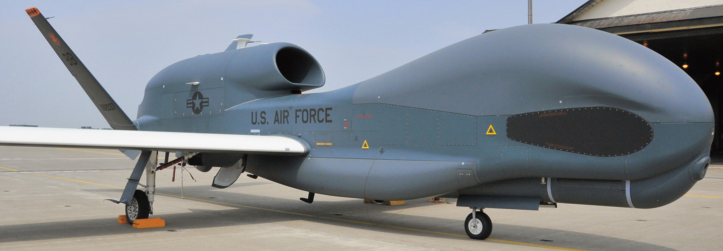
The U.S. government uses the Global Hawk, an unmanned aircraft, to study weather around the world.

The Asahi Shimbun via Getty Images

STANDARDS

CCSS: 5.G.A.2, MP3, MP6, MP7

TEKS: 5.8B

Hurricane Hunters

Scientists use technology to track extreme weather 

When Holger Vömel boarded a propeller plane last September, he knew he was in for the ride of his life. The scientist at the National Center for Atmospheric Research in Boulder, Colorado, was about to fly into the eye of Hurricane Irma. Irma was one of 2017’s strongest hurricanes. 

The closer Vömel’s plane got to the eye of the storm, the more turbulent the flight became. “You needed a seat belt or you might be thrown out of your seat,” he says. It rained so hard “it looked like the window was being sprayed with a fire hose.”  

Holger Vömel boarded a propeller plane last September. He knew he was in for the ride of his life. He’s a scientist who works at the National Center for Atmospheric Research in Boulder, Colorado. He was about to fly into the eye of Hurricane Irma. Irma was one of 2017’s strongest hurricanes.

Vömel’s plane got closer and closer to the eye of the storm. Then the flight became more turbulent. “You needed a seat belt or you might be thrown out of your seat,” he says. It rained very hard. “It looked like the window was being sprayed with a fire hose,” he says. 

EPA/NASA (hurricane); Courtesy of NCAR

Holger Vömel

Vömel and a team of scientists, pilots, and technicians had taken off from Lakeland, Florida, to follow the developing storm. Their mission: Collect information on the hurricane so weather scientists can measure it and predict what it will do next.  

Weather is complex and constantly changing. Wind patterns, water vapor, and temperature interact in Earth’s atmosphere to produce everything from a super-sunny day to a hurricane. 

Knowing about bad storms in advance is critical. People’s ability to prepare for severe weather can be a matter of life or death. Fortunately, improvements in technology have helped the science of weather forecasting become more accurate and reliable.

Vömel and a team of scientists, pilots, and technicians had taken off from Lakeland, Florida. The wanted to follow the developing storm. Their mission: Collect information on the hurricane. Weather scientists would use it to measure the storm. They would also predict what it would do next. 

Weather is complex and constantly changing. Wind patterns, water vapor, and temperature interact in Earth’s atmosphere. Weather produces everything from a super-sunny day to a hurricane. 

Knowing about bad storms in advance is critical. People’s ability to prepare for severe weather can be a matter of life or death. Fortunately, improvements in technology have helped the science of weather forecasting. It’s become more accurate and reliable.

Gathering Storm Data

One of the best ways to learn about a hurricane is to collect data from inside the storm itself. To do that, scientists use dropsondes (DROP-sahndz). These single-use sensors are roughly the size and shape of a paper towel roll. They detect wind, temperature, atmospheric pressure, and humidity—the amount of water vapor in the air. 

Once released from a plane, dropsondes collect data as they fall and transmit it to scientists. Typically, scientists release about 10 to 90 dropsondes into a storm during a flight.  

One of the best ways to learn about a hurricane is to collect data from inside the storm itself. To do that, scientists use dropsondes (DROP-sahndz). These single-use sensors are roughly the size and shape of a paper towel roll. They detect wind, temperature, and atmospheric pressure. They also detect humidity. That’s the amount of water vapor in the air.

Once released from a plane, dropsondes collect data as they fall and transmit it to scientists. Typically, scientists release about 10 to 90 dropsondes into a storm during a flight.  

HENRY FOUNTAIN/The New York Times/Redux

Leonard Miller, a technician with the National Oceanic and Atmospheric Administration, tests a dropsonde, an instrument package that measures and transmits various atmospheric data.

Vömel designs dropsondes. He joined the Hurricane Irma team to observe how these tools work during a storm. During the flight, the team flew into Irma’s eye, or a hurricane’s center, four times. 

Though dropsondes have existed for almost 60 years, newer technology has made them more precise. Data can be transmitted faster. This means it can be used to make predictions more quickly.

But a dropsonde can be used only once. Many of them litter the ocean floor. So people are working on developing new versions that use more eco-friendly
materials.

Vömel designs dropsondes. He joined the Hurricane Irma team to observe how these tools work during a storm. During the flight, the team flew into the center of Hurricane Irma four times.

Dropsondes have existed for almost 60 years. Newer technology has made them more precise. Data can be transmitted faster. The information can be used to make predictions more quickly.

But a dropsonde can be used only once. Many of them litter the ocean floor. So people are working on developing new versions that use more eco-friendly materials.

NASA/NOAA via AP Photo

Flying High

Vömel’s plane flew about 10,000 feet above Earth. Other weather planes fly much higher.

The Global Hawk is an unmanned aircraft used by NASA and the National Oceanic and Atmospheric Administration (NOAA). The 48-foot plane flies 60,000 feet (11 miles) above Earth. It has five scientific instruments on board. 

Because it operates without people onboard, the plane often spends 24 hours in flight. That’s about three times longer than a propeller plane can fly. “This means we can observe the entire storm as it develops,” says Gary Wick, a physicist at NOAA.  

Amber Emory, a meteorologist at NASA, has worked with the Global Hawk program since it began in 2009. So far, the collected data has resulted in “a big increase in our ability to forecast a hurricane accurately,” she says.

Vömel’s plane flew about 10,000 feet above Earth. Other weather planes fly much higher.

The Global Hawk is an unmanned aircraft used by NASA and the National Oceanic and Atmospheric Administration (NOAA). The 48-foot plane flies 60,000 feet (11 miles) above Earth. It has five scientific instruments on board.

The plane often spends 24 hours in flight. That’s about three times longer than a propeller plane can fly. The Global Hawk can do this because it operates without people onboard. “We can observe the entire storm as it develops,” says Gary Wick, a physicist at NOAA.

Amber Emory is a meteorologist at NASA. She has worked with the Global Hawk program since it began in 2009. So far, the collected data has resulted in “a big increase in our ability to forecast a hurricane accurately,” she says.

Hurricane Harvey is a recent example. This destructive storm struck Texas and Louisiana in August 2017, with high winds and 52 inches of rain in places.

Initially, scientists classified Harvey as a Category 2 storm (see Hurricane Categories). But after studying data from the Global Hawk, they upgraded the storm to a Category 4. “A Category 4 storm is a completely different monster,” says Emory. That much of a difference makes many people evacuate for safety reasons rather than stay home.

Hurricane Harvey is a recent example. This destructive storm struck Texas and Louisiana in August 2017. The storm had high winds and 52 inches of rain in some places.

Initially, scientists classified Harvey as a Category 2 storm (see Hurricane Categories). But after studying data from the Global Hawk, they upgraded the storm to a Category 4. “A Category 4 storm is a completely different monster,” says Emory. That much of a difference makes many people evacuate for safety reasons rather than stay home.

Safety First

Storms can be predicted, but they can’t be prevented. When severe weather hits, scientists and government officials work together to notify the public. “There is a personal side for why we do this,” says Emory. “What drives me every day is making sure people are safe during a storm.” 

Storms can be predicted. But they can’t be prevented. When severe weather hits, scientists and government officials work together to notify the public. “There is a personal side for why we do this,” says Emory. “What drives me every day is making sure people are safe during a storm.” 

The Global Hawk took off at point A. What are the coordinates of point A?

The Global Hawk took off at point A. What are the coordinates of point A?

The Global Hawk is tracking a storm that is 5 units above point A. What are the coordinates of the storm?

The Global Hawk is tracking a storm that is 5 units above point A. What are the coordinates of the storm?

Plot this point on the grid and label it point S. 

Plot this point on the grid and label it point S. 

The storm, S, moved 6 units to the right and down 2 units. Plot the new coordinates and label the point T.

The storm, S, moved 6 units to the right and down 2 units. Plot the new coordinates and label the point T.

How many square units away is Global Hawk (point A) from point T? 

How many square units away is Global Hawk (point A) from point T?

A few hours later, the storm has moved to point U. The Global Hawk is now at point B. What are the coordinates for points U and B?

A few hours later, the storm has moved to point U. The Global Hawk is now at point B. What are the coordinates for points U and B?

The next day, the storm has moved halfway between points U and B. A student plots this point and its coordinates as (5,4). Is the student right or wrong? Explain. 

The next day, the storm has moved halfway between points U and B. A student plots this point and its coordinates as (5,4). Is the student right or wrong? Explain. 

Plot point A from question 1 on the grid above. Explain how the Global Hawk moved 11 units between points A and B.

Plot point A from question 1 on the grid above. Explain how the Global Hawk moved 11 units between points A and B.

technicians

People who work with specialized equipment as a job

coordinates

A pair of numbers in an ordered pair, used to locate a point on a coordinate grid in the form (x,y)

Example: (2,3) denotes the point two units to the right on the x-axis and three units up on the y-axis

transmit

To send out radio, television, or other signals

interact

Work together

units

An amount that can be used as a standard of measurement

Example: if you have 5 basketballs, the amount is 5 and your unit is basketballs

unmanned

Not controlled by people onboard 

reliable

Able to be trusted

meteorologist

An expert who studies the earth’s atmosphere, especially in relation to climate and weather

sensors

Instruments that can detect and measure information and transmit it to a controlling device

turbulent

Rough and wild

evacuate

To move away from an area or building because it is dangerous there

precise

Very accurate or exact

prevented

Stopped

propeller plane

A small plane driven forward by a set of rotating blades

videos (1)
Skills Sheets (7)
Skills Sheets (7)
Skills Sheets (7)
Skills Sheets (7)
Skills Sheets (7)
Skills Sheets (7)
Skills Sheets (7)
Lesson Plan (2)
Lesson Plan (2)
Text-to-Speech